Choosing the right ground blind or treestand locations can draw the line between success and failure — especially for bowhunters, who know that just a few yards can be a difference maker. Using topo maps, aerial photos and satellite imagery in conjunction with a GPS provides useful intel when deciphering where to begin your scouting efforts, and ultimately where to strategically place stands. I use this information as the framework for how and where I begin my legwork.
Here are four terrain features that will help get you up close and personal with big bucks this fall.
Work the Inside Corners
Deer often use inside corners as they travel because they provide the shortest distance between two points. Go to a park or other public places where one sidewalk meets another at a 90-degree angle and you’ll see where people routinely cut the corner instead of following the sidewalk. Deer do the same thing. I also believe that deer often enter fields via inside corners because it allows them to see a larger portion of the field while staying in cover. And there are often the spoils of agriculture left in these tight corners that large combines cannot easily get to, providing a mini food source for deer.
These are good places to begin your scouting efforts and often translate into excellent stand locations because they funnel deer movement and provide for multiple wind options.
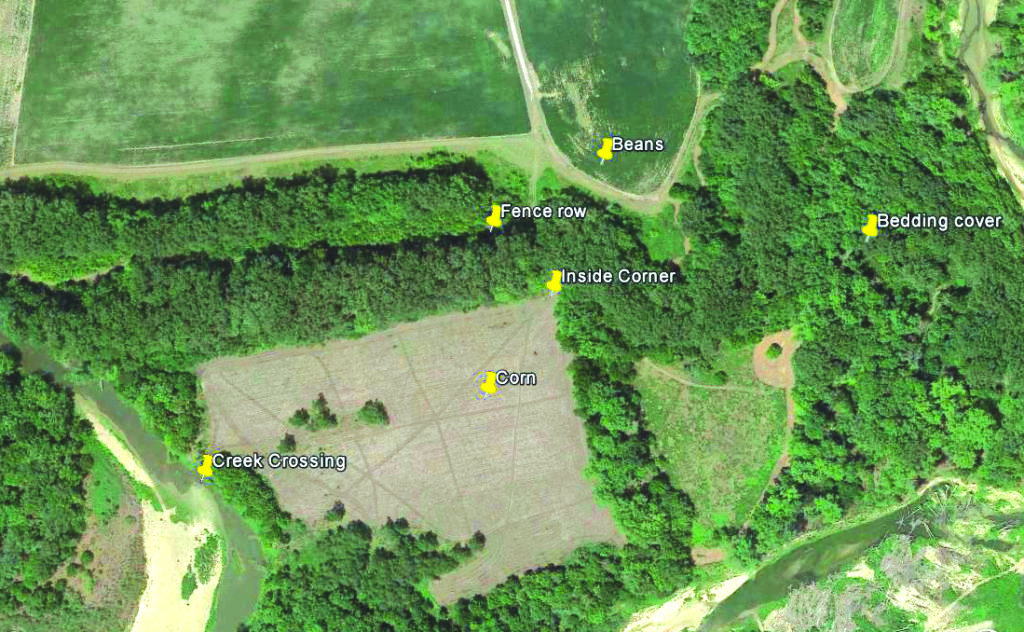
Also look for inside corners where two fencelines intersect, forming a point. I have killed more bucks along fencelines than any other feature both in the big woods and on agricultural lands. Nothing directs deer movement more readily than a fence, especially the inside corners.
Find the Funnels
Funnels provide another productive stand site option and are easily identified. There are several types to consider.
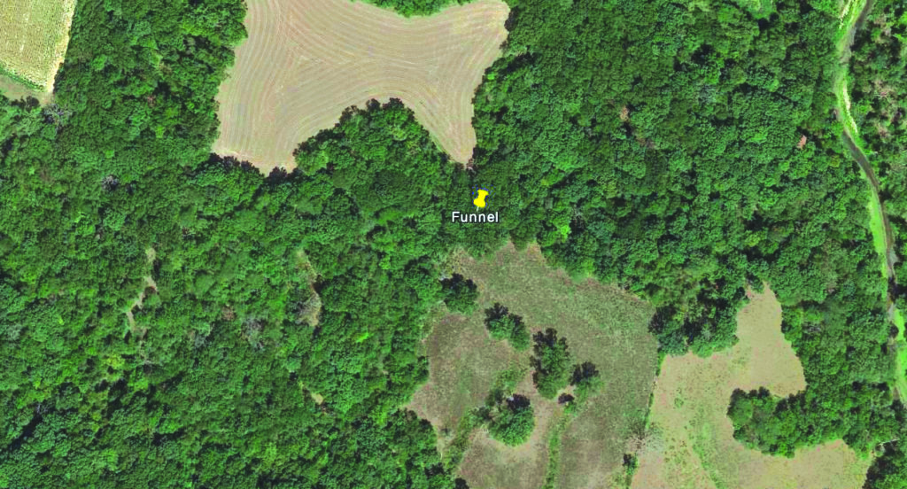
Woodlot funnel: This is a strip of cover 10 to 100 yards wide that connects large woodlots. Deer crossing from one lot to the next get “funneled” into these narrow strips of cover.
Landscape funnel: This is where a wash or another topography feature creates a physical funnel that deer use because it provides easier access to the top of a hill or other destination. Hill top fields or pastures often have this characteristic leading up from a creek-bottom or lowland woodlot below.
Field funnel: This is better described as a peninsula of trees jutting out into a field that deer feed in. Deer often enter fields through these funnels so they can remain in cover as long as possible before exposing themselves. Also, to minimize the time spent out in the open they use these peninsulas to cross the field because it provides the shortest exposed route from one side of the field to the other.
Saddles Can Be High Traffic Features
Saddles are low points in ridgelines that offer the easiest place for a deer to cross from one side of a ridge or mountain to another and funnel deer from Point A to Point B. Wind plays an important role here because it will often be multi-directional, meaning it might be blowing from north to south but will often create a swirling effect and carry your scent back the way the wind was coming from. This is evident in many hilltop setups and must be accounted for when setting up stands.

Saddles can also be and often are formed by intersecting ridgelines. A ridgeline will almost always have a trail at the very top, and when you have two ridges coming together at a low point or “saddle,” you will often have higher traffic in those areas because there might be as many as four or more main trails converging.
Edges Are Where It’s At
Edges are simply where one type of terrain meets another, such as where a swamp or burned area meets timber, and are big woods hotspots.
Before man started altering the landscape, Mother Nature created edges and breaks with fire, wind and water. It is at these breaks where deer often find the best food sources in close proximity to cover.

When I moved out West, it was an adjustment to learn how to locate deer in timber and other areas void of agriculture. I learned to glass and stalk for deer instead of intercepting them. I would almost always find deer on the edges of burns, logging clear-cuts, riparian low lands and in areas where ponderosa pines transition to oak scrub or juniper stands. This got me to investigate those areas more closely. I began looking for ways to intercept these seemingly “patternless” deer. I would sit and watch deer for weeks leading up to hunting season to get an informed idea of where I could set up a blind or stand.
Read: Careful Timber Management is Crucial
The edges of burns and clear-cuts that are about 2 to 5 years old, depending on rainfall and winds, are usually good places to begin looking for sign. Riparian areas will almost always have game sign because of the constant new growth and water. Swamp edges especially, where there is a large break in the tree canopy, have a way of producing reclusive bucks.
It’s hard to overstate the importance of identifying and utilizing specific terrain features when it comes to patterning deer. By using inside corners, funnels, saddles and edges you can stack the odds in your favor this fall.